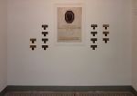
series of 2 plates, each of brass (21,5 x 8 cm) and iron (7 x 7 cm)
Intervention, former Cartographic Institute, Vienna, 2010 - ongoing
There are two metal plaques at the main entrance of the Cartographic Institute in Vienna indicating the function of the building: A benchmark and above it the inscription »200.272 Meter über dem Adriatischen Meere« / »200.272 metres altitude above the Adriatic Sea«. These specifications refer to the average water level of the Adriatic Sea at the Molo Sartorio in Triest in the year of 1875.
The building, which was founded as the second building of the Military Cartographic Institute by the K.u.k. Monarchy, served the purpose of producing the maps needed for the army.
With our project »Azimuth« we link up to the political dimension of the precisely fixed constants of earth's geographical and political structure in form of demarcation and the building of national states.
In the field of cartography Azimuth (arabic: as-sumut – the directions) means the angle measured clockwise between a geographical north and any direction south on earth.
Each year thousands of people are dying when they try to cross existing definitions of borders – especially from south to north. Also when migrating to the European Union. Since 1993 organisation »UNITED« (»European network against nationalism, racism, fascism and in support of migrants and refugees« based in Amsterdam, NL) has documented 13824 refugees who were killed related to border militarisation, asylum laws, accommodation, detention policies, deportations, carrier sanctions and so forth.
Mostly the dead remain unidentified, the definite exact time of death is not clear and the locations of the death stay vague.
On the formal aspect we refer to the form of the two entrance plaques. Instead of an exact position-fixing we have engraved the not exact dates of the deaths. Instead of an exact benchmark we have engraved a rough guess of the azimuth.


